☰

Singapore, 2 August 2022 – The National Environment Agency (NEA) and the Singapore Land Authority (SLA) have signed a Memorandum of Understanding (MOU) to develop the use of Global Navigation Satellite System (GNSS) data obtained from SLA’s Singapore Satellite Reference Network (SiReNT) to enable NEA to better monitor island-wide atmospheric moisture. The five-year collaboration is aimed at benefitting Singapore with additional data for weather monitoring, as well as facilitating exploratory studies for weather forecasting.
1 The slowing down of GNSS signals when travelling through a moist atmosphere can be estimated and used to derive the amount of moisture between the satellite and ground receiver.
 2 NTU Singapore and Singapore Land Authority collaborate to use satellite data for environment research (sla.gov.sg)
services and applications in various key industries currently supported by SiReNT. It can also be further leveraged for novel uses in climate-related scientific studies (refer to Annex B for a background of SLA’s SiReNT station network).
For media queries, please contact:
Siti Annazia Hamsani (Ms) Corporate Communications National Environment Agency Tel: 9844 6309
Email: [email protected]
Adrian Tan (Mr)
Corporate Communications & Engagement Division Singapore Land Authority
Tel: 9857 5976
Email: [email protected]
The National Environment Agency (NEA) is the leading public organisation responsible for ensuring a clean and sustainable environment for Singapore. Its key roles are to improve and sustain a clean environment, promote sustainability and resource efficiency, maintain high public health standards, provide timely and reliable meteorological information, and encourage a vibrant hawker culture. NEA works closely with its partners and the community to develop and spearhead environmental and public health initiatives and programmes. It is committed to motivating every individual to care for the environment as a way of life, in order to build a liveable and sustainable Singapore for present and future generations.
For more information, visit www.nea.gov.sg
Connect with us on Facebook | Instagram | Telegram | Twitter | YouTube | LinkedIn | TikTok
Singapore Land Authority (SLA) is a statutory board with the Ministry of Law. Its mission is to optimise land resources for the social and economic development of Singapore. SLA manages some 11,000 hectares of State land and about 2,700 State properties, which have largely been tenanted out for a variety of uses. It also manages land sales, leases, acquisitions and allocation, developing and marketing land-related information, and maintaining the national land information database through digitised land information services. Being the national land registration authority for property transactions, SLA issues and guarantees land titles in Singapore. It also manages and maintains the national land survey system, where boundaries or legal limits of properties are defined, based on a coordinated cadastre survey system. The use of geospatial information is also spearheaded by SLA through a national collaborative environment where geospatial data, policies and technologies are established and defined, thereby fostering innovation, knowledge and value creation for the Government, enterprises and community.
For more details on SLA, visit www.sla.gov.sg or find us on LinkedIn, Facebook and Instagram @SingaporeLandAuthority.
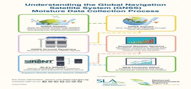
Infographic on Understanding the Global Navigation Satellite System (GNSS) Moisture Data Collection Process
Background of the Satellite Reference Network (SiReNT)
Developed by the Singapore Land Authority (SLA) in 2006, the Singapore Satellite Positioning Reference Network (SiReNT) is a national reference network infrastructure that supports real-time high precision positioning, navigation, and monitoring of up to 3cm. The technology is used by Government agencies and private companies in applications where precise positioning is required. This includes the development and operation of self-mobility platforms, construction automation and high accuracy mapping.
2 More information on SiReNT can be found on https://app.sla.gov.sg/sirent/.

Image 1: The GNSS Reference Station on Sultan Shoal (SSTS) Photo credit: Singapore Land Authority (SLA)
Photo credit: Singapore Land Authority (SLA)
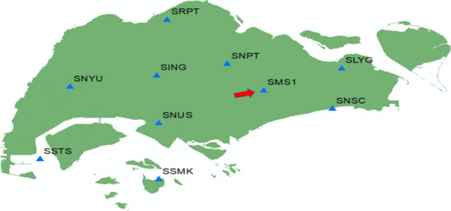
Image 2: Locations of SiReNT GNSS Reference Stations. The name of the new NEA station at Kim Chuan is SMS1.
Photo credit: Singapore Land Authority (SLA)
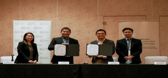
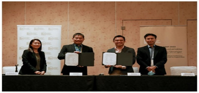
Mr Luke Goh, Chief Executive, National Environment Agency (NEA) (second from left) and Mr Colin Low, CEO of Singapore Land Authority (SLA) (second from right) signed the Memorandum of Understanding to share Global Navigation Satellite System (GNSS)-derived moisture data for weather monitoring application at the World Cities Summit 2022. The signing was witnessed by Ms Koh Li-Na, Assistant Chief Executive, NEA (first from left) and Mr Bryan Chew, Assistant Chief Executive, SLA (first from right).

As per the reports, four prominent Chinese tech companies, including Baidu Inc and SenseTime Group, have reportedly introduced their artificial intelligence chatbots to the public, after securing the necessary government approvals. This development a...

Equinor, a Norwegian energy company, along with its collaborators, reportedly inaugurated the largest floating offshore wind farm situated in Norway. This significant achievement, unveiled on Wednesday, involves harnessing wind energy to supply power...

Krafton, a prominent gaming company from South Korea, has reportedly announced its intention to inject an additional $150 million into the Indian market within the next 2-3 years. This move comes as a positive development for the InDIAN gaming indust...
© 2026 ReportsGO.com. All Rights Reserved.

